
Home / Guides / SWPPP site map
SWPPP site map requirements
EPA's 2022 Construction General Permit requires a legible site map, or series of maps, showing the property boundary, where soil will be disturbed (with phasing), slopes before and after grading, stockpiles, vehicle exits, final structures, receiving waters within the site and one mile downstream, drainage patterns, discharge points, pollutant-generating activities such as concrete washout, and every stormwater control. EPA 2022 CGP Part 7.2.4 The map is updated within 7 days when the site or its controls change. EPA 2022 CGP Part 7.4.1 State permits have their own lists: Mississippi asks for a scaled map with a north arrow and contours. MSR10 ACT5 T-13
National guide. The rules cited are from EPA's 2022 Construction General Permit (as modified in 2025), checked October 20, 2026, which applies where EPA is the permitting authority. Most states issue their own permit with different details; check your state before relying on a number.
Sources last checked October 19, 2026. Prepared by our team led by Mohamed Elansary, PhD, with AI research tools. We are not a licensed engineering firm and do not seal plans.
General information; your permit text controls. Not legal advice and not engineering judgment. We make no promise of permit coverage, agency acceptance or compliance.
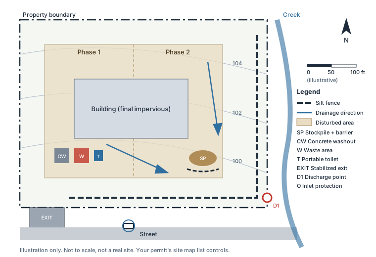
What the map must show
| Item | EPA 2022 CGP 7.2.4 | Texas TXR150000 | Mississippi MSR10 |
|---|---|---|---|
| Property boundary | Yes | Yes | Yes, with proposed construction activities |
| Disturbed areas and phasing | Yes, including demolition | Yes, including demolition | Yes, noting phasing |
| Slopes or contours | Approximate slopes before and after grading; steep slopes noted | Approximate slopes before and after major grading | Original and proposed contours if feasible; steep slopes identified |
| Drainage patterns | Before and after grading, for stormwater and allowed non-stormwater | Before and after major grading | Drainage pattern arrows |
| Receiving waters | Within the site and within one mile downstream of discharge points, flagged if impaired or Tier 2, 2.5 or 3 | At, adjacent to or near the site, flagged if impaired; one mile downstream | Sensitive areas such as wetlands, perennial streams and adjacent water bodies; if off the map, name and direction in text |
| Discharge points | Inlets (noting whether they drain to a basin or trap), direct discharges, turbidity monitoring points | Direct discharges to surface water or an MS4 | Storm drain inlets and any receiving MS4 |
| Controls | All stormwater controls, natural buffers and shared controls | All controls and buffers; stabilization areas | All erosion and sediment controls; post-construction controls; buffer zone location and size |
| Stockpiles and exits | Stockpiles; vehicle exits onto paved roads; receiving water crossings | Vehicle exits; vehicle wash areas | Construction entrance; laydown area |
| Activities | Pollutant-generating activities (paving, washout, waste, dewatering); support activity areas; treatment chemical storage; non-pollutant waste storage | Construction support activities, including off-site; concrete washout areas | Equipment maintenance, concrete washout, waste, material and chemical storage; housekeeping practices |
| Other | Final structures and impervious surfaces; pre-construction cover; federally listed critical habitat | A separate general location map (for example part of a city or county map) | North arrow; scaled map; flocculant points and settling BMPs if flocculants are used |
Sources: EPA 2022 CGP Part 7.2.4, footnotes 87-88 TXR150000 Part III.F.1(f)-(g) TXR150000 Part VI.E MSR10 ACT5 T-13
Where one map would be hard to read, both EPA and Texas allow a series of maps that together show everything. EPA 2022 CGP Part 7.2.4 TXR150000 Part III.F.1(g) EPA only requires storm drain inlets near the site to be shown if they are easy to identify from the site or a public area next to it. EPA 2022 CGP Part 7.2.4, footnote 88 Mississippi's coverage application also asks for a USGS quadrangle map extending at least half a mile beyond the site boundaries, separate from the SWPPP site map. MSR10 ACT4 S-2
When to update the map
- Within 7 days of a change in construction plans, controls or activities that the SWPPP no longer reflects, when a new operator becomes active, or when operational control of an area is transferred (show the area and date). EPA 2022 CGP Part 7.4.1
- After an inspection finds a needed change, update the map under Part 7.4.1 and keep records of the modification dates. EPA 2022 CGP Part 4.6.4, 7.4.2
- Texas: revise the SWP3, including the site map, within 7 days of a change. TXR150000 Part III.E
Moving a washout, stockpile or vehicle exit is a change the map has to show within those 7 days under EPA's permit. EPA 2022 CGP Part 7.4.1 After each inspection, EPA requires the site map to be modified to show any changed stormwater controls. EPA 2022 CGP Part 4.6.4
Related: what goes in a SWPPP, silt fence installation, concrete washout rules, SWPPP inspection requirements. State rules: Alaska, Arizona, Arkansas, Colorado, Florida, Hawaii, Idaho, Illinois, Indiana, Iowa, Kentucky, Louisiana, Massachusetts, Michigan, Mississippi, Nebraska, Nevada, New Hampshire, New York, North Dakota, Ohio, Oklahoma, Oregon, South Carolina, South Dakota, Texas, Utah, Washington, West Virginia.
Our plans include the site map list written to the permit that covers your site. The permit list above, not the example drawing, decides what your map must show.
What this page does not cover
Survey, civil drawings, grading design and local plan-sheet standards. The example map is illustrative and does not represent any real site.
Have it written for you
SWPPP Desk prepares site-specific SWPPPs from your drawings for construction sites in the states we cover (coverage by state), for a fixed price, delivered the next business day after your inputs are complete. Small site (1 to under 5 acres): $449. Large site (5 acres or more): $749. Background: all guides.
Related guides
- What is a SWP3?
- What is a SWPPP?
- SW3P, SWP3 and SWPPP: the same plan
- TCEQ SWPPP requirements
- TXR150000: the Texas construction general permit
- TCEQ stormwater permit for construction
- TCEQ NOI: filing in STEERS
- What goes in a SWPPP plan
- SWPPP template: EPA and state templates
- SWPPP inspection requirements
- SWPPP inspection form
- Erosion control plan requirements
- Who needs a SWPPP?
- Notice of Intent (NOI) for construction stormwater
- Notice of Termination (NOT)
- SWPPP sign and site notice
- Construction stormwater BMPs by type
- SWPPP cost: our prices and public prices
- PROPOSED 2027 EPA CGP: what re-filing looks like
- TXR150000 renewal: the permit expires March 5, 2028
- Silt fence installation
- Sediment basin requirements
- Concrete washout rules
- Construction dewatering